


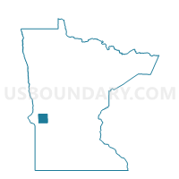
Stevens Twp. Voting District, Stevens County, Minnesota
About
Outline

Summary
| Unique Area Identifier | 604571 |
| Name | Stevens Twp. Voting District |
| County | Stevens County |
| State | Minnesota |
| Area (square miles) | 35.95 |
| Land Area (square miles) | 35.74 |
| Water Area (square miles) | 0.21 |
| % of Land Area | 99.41 |
| % of Water Area | 0.59 |
| Latitude of the Internal Point | 45.45330530 |
| Longtitude of the Internal Point | -96.17843170 |
Maps


Graphs
Select a template below for downloading or customizing gragh for Stevens Twp. Voting District, Stevens County, Minnesota


Neighbors
Neighoring Voting District (by Name) Neighboring Voting District on the Map
- Artichoke Twp. Voting District, Big Stone County, MN
- Baker Twp. Voting District, Stevens County, MN
- Hegbert Twp. Voting District, Swift County, MN
- Malta Twp. Voting District, Big Stone County, MN
- Otrey Twp. Voting District, Big Stone County, MN
- Scott Twp. Voting District, Stevens County, MN
- Synnes Twp. Voting District, Stevens County, MN
Top 10 Neighboring County Subdivision (by Population) Neighboring County Subdivision on the Map
- Scott township, Stevens County, MN (144)
- Synnes township, Stevens County, MN (118)
- Baker township, Stevens County, MN (114)
- Malta township, Big Stone County, MN (98)
- Hegbert township, Swift County, MN (93)
- Otrey township, Big Stone County, MN (87)
- Artichoke township, Big Stone County, MN (79)
- Stevens township, Stevens County, MN (77)
Top 10 Neighboring Unified School District (by Population) Neighboring Unified School District on the Map
- Lac Qui Parle Valley School District, MN (6,541)
- Ortonville -Bellingham Public School District, MN (3,549)
- Clinton-Graceville-Beardsley Public School District, MN (2,587)
- Chokio-Alberta Public School District, MN (1,235)
Top 10 Neighboring State Legislative District Lower Chamber (by Population) Neighboring State Legislative District Lower Chamber on the Map
Top 10 Neighboring State Legislative District Upper Chamber (by Population) Neighboring State Legislative District Upper Chamber on the Map
Top 10 Neighboring 111th Congressional District (by Population) Neighboring 111th Congressional District on the Map
Top 10 Neighboring Census Tract (by Population) Neighboring Census Tract on the Map
- Census Tract 4801, Stevens County, MN (2,426)
- Census Tract 9604, Swift County, MN (2,241)
- Census Tract 9501, Big Stone County, MN (1,516)